
MAGNITUDE 5.6 – EASTERN HONSHU, JAPAN
http://earthquake.usgs.gov/earthquakes/eventpage/usc000p20r#summary
Subject To Change
Depth: 55 km
Distances: 12km (7mi) SW of Kamaishi, Japan
14km (9mi) NNE of Ofunato, Japan
22km (14mi) SSW of Otsuchi, Japan
24km (15mi) SE of Tono, Japan
430km (267mi) NNE of Tokyo, Japan

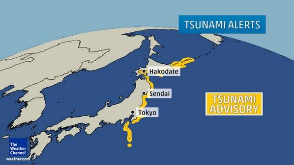
Small tsunami (0.3 to 1.3 feet) reported at 9 locations in Japan
Small tsunami (0.3 to 1.3 feet) reported at 9 locations in Japan in past hour from Chile quake. Advisory continues
**EXTREMELY URGENT**MASSIVE DIP SPIKE ON THE MAGNETOSPHERE


***ALERT***Peru Volcano Prompts Evacuations

A volcano in southwestern Peru called Ubinas began ejecting pyroclastic material into the sky in 2006, after over four decades of lying dormant. Recent volcanic activity has prompted officials to evacuate 60 residents of Querapi, a village near its base. The last state of emergency due to Ubinas activity occurred on April 23, 2006.
Ubinas town mayor Pascual Coaquira said the villagers were relocated Saturday, and that residents of the town of Ubinas have been distributed masks and goggles, as the building ash content in the air has made it difficult for some to breathe.
Portions of Peru lie in the Andean Volcanic Belt, which is comprised of four main volcanic zones. The stratovolcano Ubinas lies in the Central Volcanic Zone (CVZ) of the belt, a series of volcanoes formed due to subduction of the Nazca Plate under western South America along the Peru-Chile Trench.

Ubinas is situated in southwestern Peru, and its upper slopes are primarily made up of of Pleistocene andesitic lava flows, and steepen to nearly 45 degrees. The steep walls allowed for the debris-avalanche from the collapse of the southeast flank of volcano to extend 6.2 miles. In the larger Moquegua region, including Arequipa and Tacna, there are roughly 40 volcanoes, most of which are inactive.
Coaquira added, “We are readying a shelter for refugees from the blasts. The volcano has been emitting a lot of ash all day, the people in the town (of Ubinas) are having some problems breathing.”
Ingemmet, Peru’s geological and mining agency, stated that lava had been building up in recent weeks, and warned locals they should prepare for the possibility of more evacuations. Fortunately, the type of lava from the stratovolcano is viscous and moves very slowly, while cooling and hardening quickly.
The Ubinas volcano is located in the Moquegua region, roughly 43 miles from the city of Arequipa.
MAGNITUDE 5.4 – OFFSHORE TARAPACA, CHILE
Subject To Change
Depth: 21 km Distances: 43km (27mi) WSW of Iquique, Chile
196km (122mi) N of Tocopilla, Chile
208km (129mi) S of Arica, Chile
260km (162mi) S of Tacna, Peru
494km (307mi) SSW of La Paz, Bolivia

MAGNITUDE 5.1 – OFFSHORE TARAPACA, CHILE
Subject To Change
Depth: 10 km Distances: 71km (44mi) NW of Iquique, Chile
145km (90mi) SSW of Arica, Chile
198km (123mi) SSW of Tacna, Peru
246km (153mi) SSE of Ilo, Peru
445km (277mi) SW of La Paz, Bolivia
MAGNITUDE 5.1 – OFFSHORE TARAPACA, CHILE
Subject To Change
Depth: 2 km Distances: 487 km SW of La Paz, Bolivia / pop: 812,799 / local time: 07:11:32.0 2014-04-02
89 km W of Iquique, Chile / pop: 227,499 / local time: 08:11:32.0 2014-04-02

MAGNITUDE 5.4 – OFFSHORE TARAPACA, CHILE
Subject To Change
Depth: 10 km Distances: 92km (57mi) WNW of Iquique, Chile
179km (111mi) SSW of Arica, Chile
229km (142mi) SSW of Tacna, Peru
249km (155mi) NNW of Tocopilla, Chile
486km (302mi) SW of La Paz, Bolivia

MAGNITUDE 4.8 – OWEN FRACTURE ZONE REGION
http://www.emsc-csem.org/Earthquake/earthquake.php?id=369109
Subject To Change
Depth: 10 km
Distances: 1042 km S of Muscat, Oman / pop: 797,000 / local time: 14:36:42.0 2014-04-02
376 km SE of Şalālah, Oman / pop: 163,140 / local time: 14:36:42.0 2014-04-02
322 km NE of Tamrida, Yemen / pop: 8,545 / local time: 13:36:42.0 2014-04-02


Please Donate To Support My Work


Comments