Archive | August 11, 2015

MAGNITUDE 5.0 EASTERN XIZANG

http://www.emsc-csem.org/Earthquake/earthquake.php?id=454484

Subject To Change

Depth: 10 km

Distances: 614 km NE of Thimphu, Bhutan / pop: 98,676 / local time: 01:13:10.0 2015-08-12
386 km E of Lhasa, China / pop: 118,721 / local time: 03:13:10.0 2015-08-12
230 km W of Qamdo, China / pop: 86,280 / local time: 03:13:10.0 2015-08-12


Global viewRegional view

MEGA DIP SPIKES ON THE WEAK MAGNETOSPHERE @ APPROX 22:00 HRS UTC

**VERY URGENT**
  MEGA DIP SPIKES ON THE WEAK MAGNETOSPHERE @ APPROX 22:00 HRS UTC. FURTHER EARTHQUAKES, VOLCANO ACTIVITY & ADVERSE WEATHER PATTERNS WILL BE GREATLY INFLUENCED BY THE COSMIC RAYS STRIKING THE EARTH’S CORE

***BE ALERT***

Magnetogram 11.08.15  22.09 hrs UTC

Large gas line explosion in North Colorado, USA

gas explosion large_getty
A worker digging a trench on a northern Colorado ranch hit a high-pressure gas line, sparking an explosion that sent flames several hundred feet into the air and touched off a small grass fire.
 
Sean Standridge, a spokesman for the Weld County Sheriff’s Office, tells The Greeley Tribune an employee for DCP Midstream hit the 12-inch gas line at the Wells Ranch east of Lucerne on Thursday afternoon. The worker was not injured, but the trenching machine was destroyed.
 
Fire crews recommended that residents within a 2-mile radius of the fire leave their homes. The fire is in an area with few homes.
Courtesy of eaglefordtexas.com

Severe dust storm causes mayhem in Phoenix, USA

Dust Storm Alert

A rare morning dust storm tore through Phoenix Tuesday, cutting power, uprooting trees, dumping rain and leaving behind street flooding. 
 
A dust storm warning was in effect until 11 a.m. for the Greater Phoenix area and northwest Pinal County.
 
In addition, the National Weather Service issued an airport weather warning until 12 p.m. At around 10:15 a.m., the FAA was reporting delays at Phoenix Sky Harbor International Airport were running from 16 minutes to half-an-hour. 
 
Sky Harbor was reporting winds gusting up to 52 mph around mid-morning.
 
At around 11:30 a.m., after the storm blew through, Julie Rodriguez, Sky Harbor’s acting deputy aviation direction, updated activity:
“Operations are returning to normal at Phoenix Sky Harbor International Airport, but residual delays from today’s storm remain. Sky Harbor recommends that passengers and those picking up passengers at the airport check flight status with the airline before coming to the airport. At the height of today’s storm, approximately 30 inbound flights were diverted to other airports to wait out the weather. Those flights are now either on their way to Phoenix or have already arrived here.”
Salt River Project reported as many as 5,000 of its customers were without power at the height of the storm.
 
Arizona Public Service said the violent winds knocked out power to 7,000 of its customers in Phoenix, Tempe and Sun City.
 
As the storm rolled through Casa Grande, it kicked up dust and reduced visibilities, Casa Grande police tweeted.
Courtesy of kpho.com

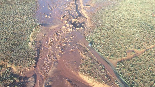
Flash Flood, Mudslide Close Northern Arizona Highway, USA; Rare Tornado Struck Too

Arizona Highway 89A north of Flagstaff closed by mudslide Aug. 9, 2015; PHOTO: AZ Department of Transportation
A storm system brought a tornado and hail to northern Arizona on Sunday, with flash flooding closing a portion of the U.S. 89A with mud and debris.
 
The Arizona Republic reported Monday that winds reached up to 70 mph Sunday afternoon about 30 miles north of Flagstaff. Meteorologist Mark Stubblefield said the tornado showed up on radar after 2 p.m. and was heading toward the 89A.
 
Transportation crews were working Monday to clear mud and boulders from the 24-mile section of highway between mileposts 531 and 555. ADOT spokeswoman Caroline Carpenter said it was unknown when the blocked portion of the highway will be reopened.
 
Stubblefield said tornadoes in Arizona are rare, but not unheard of.
Courtesy of news.azpm.org

Disaster Emergency Declared: Tons of toxins contaminate Animas River in Colorado

UNQUOTE: THIS WAS NOT A MISTAKE AS THE HEALTH & SAFETY MEASURES IN PLACE WOULD AND COULD NEVER ALLOW SUCH A CATASTROPHE TO TAKE PLACE

MAGNITUDE 5.1 KEPULAUAN BABAR, INDONESIA

http://earthquake.usgs.gov/earthquakes/eventpage/us1000314m#general_summary

Subject To Change

Depth: 143 km

Distances: 251km (156mi) WNW of Saumlaki, Indonesia
396km (246mi) SSE of Ambon, Indonesia
421km (262mi) S of Amahai, Indonesia
425km (264mi) WSW of Tual, Indonesia
428km (266mi) ENE of Dili, East Timor


MAGNITUDE 5.4 KERMADEC ISLANDS REGION

http://www.emsc-csem.org/Earthquake/earthquake.php?id=454458

Subject To Change

Depth: 10 km

Distances: 666 km S of Nuku‘alofa, Tonga / pop: 22,400 / local time: 02:35:48.8 2015-08-12
1131 km SE of Suva, Fiji / pop: 77,366 / local time: 01:35:48.8 2015-08-12
1527 km S of Pago Pago, American Samoa / pop: 11,500 / local time: 02:35:48.8 2015-08-11


Global viewRegional view

MAGNITUDE 3.6 NEPAL

http://www.emsc-csem.org/Earthquake/earthquake.php?id=454416

Subject To Change

Depth: 6 km

Distances: 2 km SE of Kathmandu, Nepal / pop: 1,442,271 / local time: 10:42:41.5 2015-08-11
2 km NE of Pātan, Nepal / pop: 183,310 / local time: 10:42:41.5 2015-08-11

   Global viewRegional view